

March is the big wild-card to those of us in the Upper South. You can have summer-like heat with temperatures in the 80s and dewpoints into the 60s, a bunch of Pacific NW style dreary 40-50 degree days, or what happened in 2015. For the 2nd year in a row a big winter storm strikes Western Kentucky, but this time setting all-time 24-hour and storm-total snowfall records, followed by a quick-hitting and brutal cold snap. The picture above is from Andrea Dawn and is from I-24 at Exit 56 in Caldwell County, after the snow ended on March 5th.
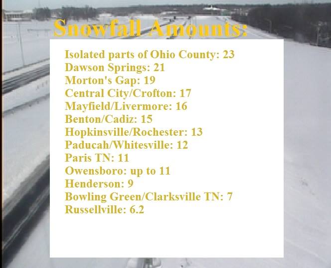
Like many of our major winter storms, this one was also caused by overrunning. A strong arctic high was in place across the Central Plains with a boundary down into MS/AL and rich southwest flow pumping copious amounts of moisture along and north of it. The arctic air did become a bit more shallow near the TN border, leading to more sleet falling from Murray to Oak Grove and over toward Bowling Green/Franklin/Scottsville which did limit the snow totals a bit to about 5 to 10 inches (which is still quite impressive), but with up to 1 inch of sleet beneath it. Just north of those areas the heaviest snowfall, with a swath of 15+ inches of snow from Mayfield through Cadiz/Dawson Springs/Central City and a maximum report of a whopping 23 inches of snow in Olaton, KY (eastern Ohio County). 6 to 8 inches of snow fell across Henderson/Owensboro.
In addition, on the morning of March 6th, Paducah set a record low of -6F which is the coldest March temperature on record. A mesonet station in Meade County set the all-time state coldest March record with a reading of -15F. Locally lows dropped into the teens below zero with Henderson (-13F) and Cadiz (-12F)
Why Was This Event Significant
- Travel was shut down, including major interstates and highways across the entire area for several days. Motorists were stranded in their cars for up to 24 hours on I-24 in Caldwell, Lyon, and Trigg Counties. Hundreds of people had to be rescued across the area due to sliding off the road or getting stuck in heavy snow. Conditions gradually began to improve on the interstates on the 6th and 7th, but it took a few more days to get everything back on track.
- Sadly at least 2 fatalities occurred (1 direct and 1 indirect) as a result of people getting stuck or involved in traffic accidents outside.
- The lows as low as -13F, were the coldest temperatures ever experienced in March and some of the coldest temperatures since the January 1994 cold snap for some people.
LINKS
https://weather.com/storms/winter/news/winter-storm-thor-snow-ice-reports
