
We get to talk about another major snowstorm with event #23. If you have read the post or personally have experienced the March 4th-5th, 2015 Winter Storm then this storm is very similar in nature to that one. I would rank this one a tad-bit higher than that one because its significant impacts occurred during a major holiday period.
Similar to the March 2015 storm we had a boundary situated over MS/AL/East TN. We had rich southwest flow that brought copious amounts of moisture into the area. In addition, we had a low-pressure system of moderate strength that tracked along this boundary from MS/AL into Eastern TN/KY/SE Ohio. We call these storms Applachian Runners because they tend to track from TX/LA/MS/AL and move north along the western edge of the Appalachian Mountains/Cumberland Plateau area. If enough cold air is available this is a really good track for Western KY winter storms.
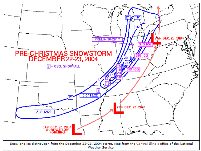
Locally we had two zones of significant winter weather, a very heavy snow zone that produced 8 to 24 inches of snow from Hickman to Benton to Dawson Springs to Cromwell and points north. Localized amounts of 24 inches (which is 2 feet) occurred in/around Henderson itself. Paducah set its all-time single-storm snow record with 14.2 inches of snow (more than its yearly average). Calhoun received 20 inches of snow with the general Owensboro area seeing anywhere from 16 to 20 inches of snow. Gusty 15-25MPH winds created drifts in excess of 3 feet in several areas. The 2nd area was just to the southeast of the heavy snow zone, where up to 2-4 inches of sleet, up to a 1/2 inch of ice, and 2 to 7 inches of snow fell from Murray to Hopkinsville to Russellville to Bowling Green. Areas in Simpson/Allen County did warm up enough to get plain rain, which did cut into their sleet/snow totals.
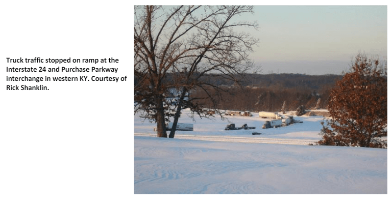
I-24 across Lyon/Caldwell/Trigg Counties was shut down stranding people in their automobiles for 24 hours. Many counties had to pull emergency vehicles off the road for several hours as conditions were too dangerous in both the heavy snow and the sleet zones. Scattered power outages occurred in areas where sleet and freezing rain were a predominant form of precipitation.
In addition to the cold temperatures as low as -8F in Paducah and -12F in Henderson occurred on Christmas Morning. This led to frozen pipes in several areas including businesses and city buildings.
Why Was This Significant
- This was a record-setting high-impact snowstorm that occurred during the Christmas season. Extra traffic was on the road which with some high-impact snow and sleet amounts led to multiple traffic issues and road closures, including major US Highways and Interstates. Damage to roofs of several buildings occurred due to the snow buildup and the brutal cold on Christmas Morning led to multiple instances of pipes freezing and then bursting.
- Paducah set its all-time snow record for a single storm along with likely places like Calhoun and Henderson. Henderson’s -12F reading wouldn’t be challenged until just over a decade later when it hit -13F after the March 4-5th, 2015 major snowstorm.
LINKS
https://www.weatherphotography.net/2004ohiovalleyblizzard1.htm
^^ Pictures from Beau Dodson in the Paducah/Lone Oak area ^^
