
Event #21 features the costliest non-December 2021 tornado to ever occur in our area. It was part of an active severe weather event that featured two F/EF-3 tornadoes, baseball-sized hail, and significant flash flooding in the Jackson Purchase. This event just occurred on the 3rd day of the new millennium. It wasn’t Y2K that caused us issues, it was the classic cool-season severe weather setup.
As this increasingly organized and strong low-pressure system moved into IL, it brought rich gulf moisture into our area with dewpoints into the 60s. CAPE values were around 500-700 J/KG, which is a bit on the low side for instability, but it is plenty enough in winter-time tornado events with significant wind shear. Repeated rounds of thunderstorms also brought significant flash flooding which did over 1 million dollars in flood damage across the Jackson Purchase with Ballard and Carlisle County being the hardest hit with closures on US 62, several homes threatened, and even a few roads washed out when a sudden 3-5 inches of rain fell across the area.
The more significant round of severe weather arrived between 3-6pm across the area. A strong squall line with embedded supercells moved into our region as seen below from the image by the National Weather Service’s Paducah radar taken at 3:05pm CST
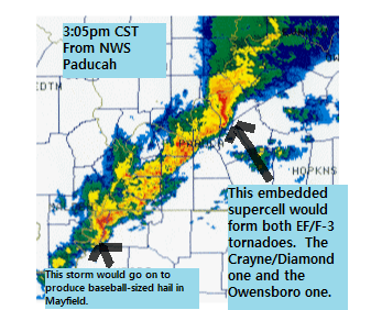
Although these storms were in a line, there were two embedded supercells that had plenty of inflow available to them. The one in Crittenden County had access to even more wind shear which allowed for it to become an effective tornado producer. The first F-3 tornado touched down in the Crayne community south of Marion at around 315pm (in Crittenden County) this tornado tracked through the southern part of the county passing just north of Shady Grove, producing 3 injuries. This tornado then moved into Webster County (intersecting the 2022 path, see event #35) before moving north of Providence and striking Diamond before lifting. This tornado caused around $12 million dollars (2024 amount) in damage, damaged and destroyed 100 homes, and caused 3 injuries in Crittenden County.
This storm then moved across Webster, NW McLean, and into Daviess County, where in Rome (just southwest of Owensboro) it produced the second and final F-3 tornado, which would directly impact central and southern parts of the city at around 4pm.
The National Weather Service of Paducah warning text (this is for January 3rd, 2000 and not today or the day you are reading this) for the Owensboro tornado is listed below, with around 20 minutes of lead time for the city of Owensboro.
"BULLETIN - EAS ACTIVATION REQUESTED
TORNADO WARNING
NATIONAL WEATHER SERVICE PADUCAH KY
343 PM CST MON JAN 3 2000

THE NATIONAL WEATHER SERVICE IN PADUCAH HAS ISSUED A

* TORNADO WARNING FOR...
  MCLEAN COUNTY IN WESTERN KENTUCKY
  SOUTHEAST HENDERSON COUNTY IN WESTERN KENTUCKY
  DAVIESS COUNTY IN WESTERN KENTUCKY

* UNTIL 415 PM CST

* AT 343 PM CST...NATIONAL WEATHER SERVICE DOPPLER RADAR INDICATED A
  TORNADO 25 MILES SOUTHWEST OF OWENSBORO...OR ABOUT 17 MILES
    NORTH OF MADISONVILLE...MOVING NORTHEAST AT 65 MPH. STATE POLICE
    REPORTED A TORNADO WITH THIS STORM AT 335 PM IN DIAMOND IN
    WEBSTER COUNTY.

* THE STORM WILL REACH ST JOSEPH AROUND 355 PM.

IF YOU ARE IN THE PATH OF THIS STORM TAKE COVER NOW."

UPDATED TEXT IS BELOW

BULLETIN - EAS ACTIVATION REQUESTED
TORNADO WARNING...RE-TRANSMISSION
NATIONAL WEATHER SERVICE PADUCAH KY
412 PM CST MON JAN 3 2000

THE NATIONAL WEATHER SERVICE IN PADUCAH HAS ISSUED A

* TORNADO WARNING FOR...
  DAVIESS COUNTY IN WESTERN KENTUCKY
  SOUTHERN SPENCER COUNTY IN SOUTHWEST INDIANA

* UNTIL 445 PM CST

* AT 410 PM CST...EMERGENCY MANAGERS REPORTED A TORNADO ON THE
GROUND AT TAMARACK ROAD AND CARTER ROAD IN THE SOUTHWEST PORTION OF
OWENSBORO. THIS STORM IS MOVING NORTHEAST AT 50 MPH.

IF YOU ARE IN OWENBORO TAKE COVER NOW.
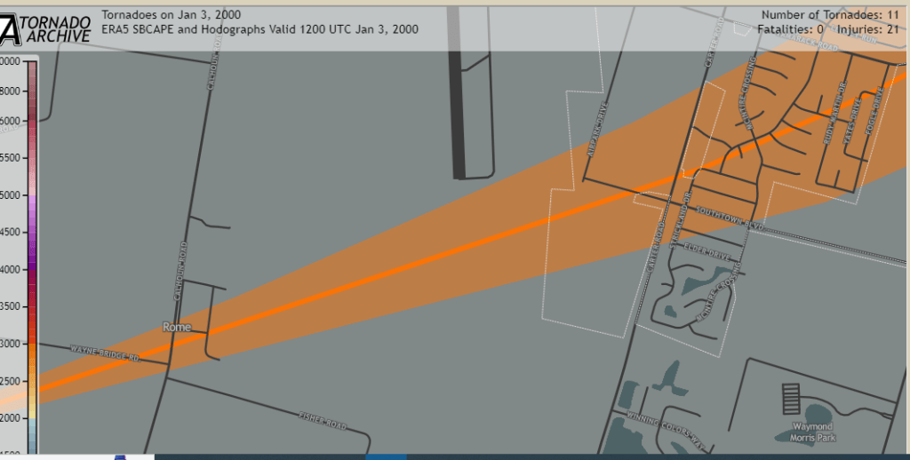

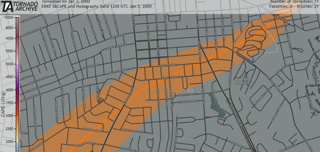
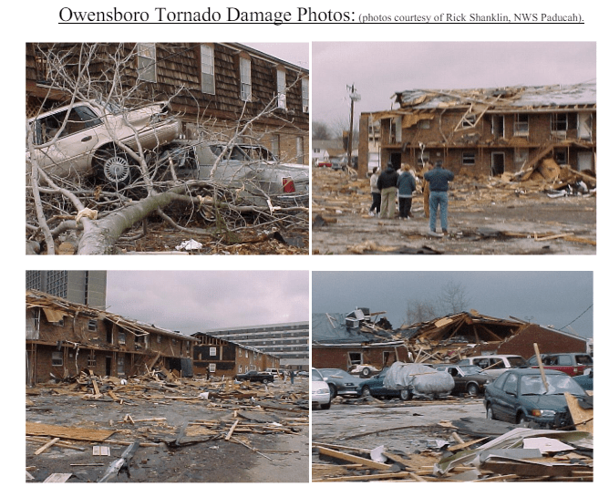
The pictures from the TornadoProject show the 15-mile track across the Rome/Owensboro areas. This tornado produced over 60 million dollars of damage (over 100 million in 2024 cost) as it moved across the area. This tornado produced 18 injuries but thankfully no deaths, heavily damaged or destroyed over 750 structures (including Apollo High School), and knocked power out for many people for days to weeks.
Why Was This Event Significant
- This produced likely the 3rd most expensive tornado in our history. Thankfully the storms weren’t deadly thanks to the great work of the National Weather Service of Paducah and the Storm Prediction Center, because these storms could have easily produced several deaths. This storm is still talked about as the most damaging storm in the history of Owensboro and Daviess County in general.
- It was also around this time where we really began to see a ramp-up in fall/winter time tornado events. Several of which we already covered such as the next time Owensboro got hit by an EF-3 tornado during the 10/18/2007 outbreak (see event #39 on our list) and the events of November 2005, February 2008, February 2018, and December 2021.
Links:
https://www.14news.com/2021/01/04/sunday-marked-st-anniversary-owensboro-tornado/
