
Overview/Setup:
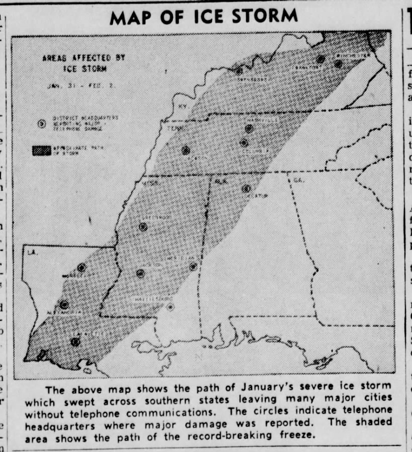
The Winter of 1950-51 was one of the most extreme and dynamic winters in our history. We had a moderate La-Nina, a brutally cold arctic region, and a steady Bermuda/Southeast Ridge. Essentially our area was constantly in the battleground zone between brutal sub-zero temperatures and springtime-like temperatures in the 60s and even 70s. At the end of January, a brutal arctic cold front moves through the area while it is raining, starting on the night of the 28th into the 29th of January. As this cold front moves through waves of energy moved along it (an overrunning setup) providing constant precipitation. This allowed for the rain to turn to freezing rain (initially the arctic air was shallow). The addition of 1 to 2 inches of rain, plus the flash freezing of the rain that fell led to a major icing event. Additional rounds of energy caused snow and sleet to fall on top of the ice.

The Snow and Ice:
The combination of freezing rain plus the freezing of water that already occurred led to major icing. This allowed for surfaces, powerlines, and trees to freeze and then in some cases collapse. As additional waves of precipitation formed in increasingly cold air the freezing rain turned to snow/sleet. A widespread 4 to 10 inches of snow/sleet fell across our entire area on top of the ice. The worst icing occurred from Murray to Marion and points southeast. The Hopkinsville and Bowling Green area were devastated by up to 4 inches of solid ice with 9 inches of snow/sleet on top of it. Travel in this area was shut down for an entire week. Coal supplies ran low and those who had electricity lost their power. This area of Western Kentucky (Hopkinsville to Bowling Green down to Franklin) saw ice amounts that were worse than both the 1974, 1994, and 2009 ice storm in that part of our area.
The Cold Snap:
A lobe of strong arctic high-pressure centered over our area (which is very rare as these usually center themselves over Canada) plus copious snow/ice accumulation areawide led to record-breaking cold. This cold snap is the worst in our area’s history. The following lows occurred on Feb 2nd which is our coldest day on record.
Bowling Green: -20F
Hopkinsville: -22F
Paducah: -14F
Princeton: -32F (at the time the all-time record low in Kentucky history)
Scottsville: -10F
This cold snap lasted about two weeks starting at the end of January with Bowling Green reporting 14 nights of sub-freezing lows, but the worst of the cold snap was during the winter storm at the end of January and the first 3 days of February.
Why Was It Significant:
This is the worst ice storm on record for the Bowling Green and Hopkinsville area and was likely one of the most significant ones for areas east of US Highway 45 until the 2009 Ice Storm. If this storm were to occur today then power outages (especially from Trigg/Christian Counties through the general Bowling Green area) would last up to 1 month.
The cold snap was the worst in our history. At the time Princeton’s -32F was the coldest ever in the state of Kentucky. It is still the coldest low temperature to ever occur in our area. If this were to happen today then we would face likely rolling blackouts or even full on disruption to the power service potentially.
Links:
https://www.weather.gov/lmk/top10winter
^^ NWS of Louisville write-up on the event ^^
^^ Bowling Green Daily News Article ^^
https://www.wbko.com/2023/12/25/top-five-ice-storms-south-central-kentucky/
^^ WBKO Top Ice Storms for Bowling Green and points south/east ^^
