
The #8 event overall and the #1 drought/heat wave event in Western KY history is a series of droughts and heat waves in the 1930s. In particular, the years of 1930, 1931, and 1936 were particularly hot.
1930-1932
Technically this was not part of the Dust Bowl, but instead was the result of a subtropical jet (due to a series of significant El-Nino events) being suppressed way to the south of our area closer to the Gulf of Mexico. 1930 was the driest year in Bowling Green (which was the main and really only climate site that was consistently operating back then across our area) with just over 30 inches of rain. Bowling Green averages around 49 inches of rain a year. To make matters worse the following winter was one of the driest on record. According to E.S Tinsdale’s article from the West Virginia Department of Health, with 1/3rd of the state of Kentucky having to adopt emergency measures to secure water supplies. Some communities had to have water transported from other areas. Especially our Pennyrile countries that have Karst aquifers because those are more prone to drought because the surface water is more connected to the underground (cave streams).
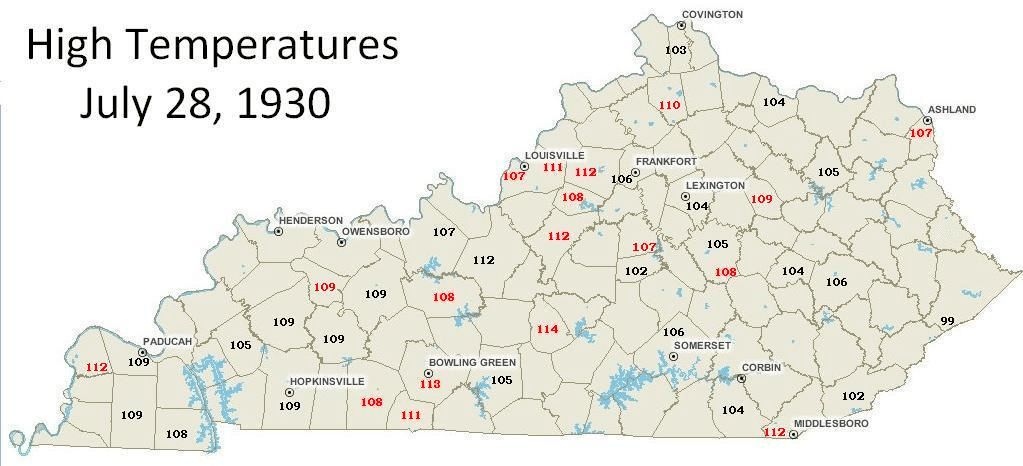
1930 was also hot as well with late July and a period in August 1930 being two of the hottest days of Kentucky in our history.
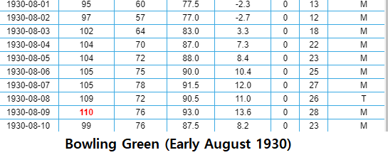
Early August of 1930 was also very hot with a straight week of 100+ weather.
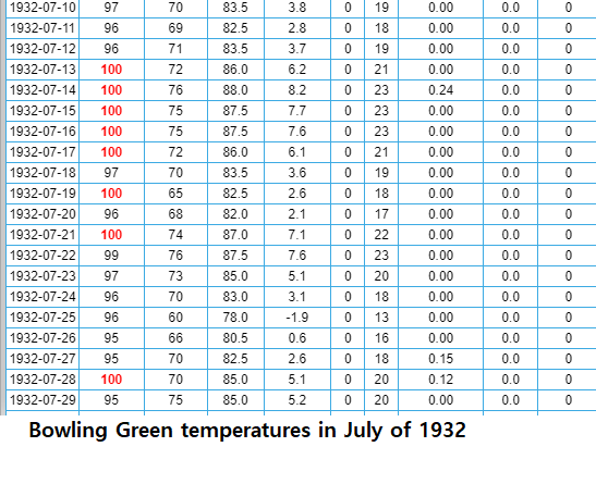
1931 was also quite hot and the first half of the year was very dry as well. Bowling Green recorded 14 days of 100+ weather in the months of June and July of 1931. Precipitation did pick up starting in August and 1932 and 1933 were both above-average in rainfall which ended that drought series. Despite 1932 being a wetter year it still had some heat wave issues as seen below with 19 straight days of 95+F high temperatures in July of that year.
1936 Drought and Heat
Drought paid a visit again in 1936. This was right when the dust bowl was really ramping up just to our west and by the Spring of 1936 the drought was pushing our way. In Bowling Green, May and June combined to produce only 1 inch of rain (the average being about 9 inches of rain during that timeframe). With the 0.12 inches of rain observed in June, making June 1936 the driest June on record.
The heat was unbearable that Summer with every single weather station in Kentucky reporting a 100F or higher reading every day from July 8th to July 15th of that year. Another brtual stretch occurred in August with Bowling Green recording 14 straight days with the temperature rising to 98F or above. Unlike the 1930 heat wave which featured some cooler night time lows here and there, the heat wave of 1936 featured many days with lows in the 70s to near 80, meaning less relief at night.

The 1930s Heat Waves Versus More Modern Heat Waves
When this topic of the 1930s heat and drought gets brought up, so does the issue of Climate Change and comparisons to the heat waves post-2000. Another question that is asked is why are years like 2012 or even 2022/2023 considered hotter than these 1930s years? One notable difference is that our nighttime lows have been on the rise with the more recent heat waves commonly featuring lows in the 80s.
One could say that is a Climate Change thing which adding more Greenhouse Gases would provide more insulation in keeping heat in during the overnight hours (that is how an actual Greenhouse keeps things warm at night and in the winter), but it is also a Urban Heat Island Effect/Land Usage thing as well. Asphalt and building materials absorb more heat from the Sun and any pollutants can even briefly have their own Greenhouse Effect to keep even larger towns like Bowling Green from cooling off as much in the nighttime. Why the 1930s may have had higher daytime high temperatures, some of our recent heatwaves were hotter overall, due to higher nighttime temperatures. A 105F high with a 67F low (mean average of 86F) is cooler than a 98F high with a 78F low (mean average of 88F). Regardless the 1930s still has an impressive array of 100+ days and multiple rounds of record dry periods that hasn’t been repeated as of June 2024, at least not yet and hopefully never in our lifetimes.
Why Was This Significant
If you look at the figure below the 1930s (especially the 1930-1932 period) clearly show this timeframe having the most widespread and intense drought. You can see a spike in the mid-1930s to definitely correspond to the 1936 period. If we had a drought like the 1930-1932 period we would likely have overall $2 Billion dollars of damage to crops, some areas would have water restrictions, and heat illness and potentially heat-related deaths would increase. This event would be more costly than the 2012 drought and any event we discussed previously or will discuss later. Several people in the 1930s suffered from illness, especially GI illnesses increased drastically because their well water ran dry. 7/28/1930 is still considered the hottest day in Kentucky history.

^^ The droughts and wet periods in the state of Kentucky ^^
