
The sun is about to set on 2018 and rise on to 2019 as Planet Earth completes one revolution around the Sun. Since I track weather as a hobby, today I will post the Top 5 Weather Events in Western Kentucky.
2018 was a fairly active year in this part of the country with a few tornado events, a double-barred winter system in January, a heat/humidity wave in the early Summer, and the absence of the transition seasons (Spring and Fall). Here is what I judge to be the Top 5 Weather Events in Western KY. This list is subjective and factors that I use to rank these events include fatalities/injuries, meteorological significance, and monetary impact.
- The February 24th Tornado Outbreak and Flooding and the River Flood Event that Followed:
https://www.spc.noaa.gov/climo/reports/180224_rpts.html
^^ Storm reports from 2/24 ^^
This event started with a supercell thunderstorm that formed in Robertson County along a warm front. This storm tracked into Logan County and produced an EF-2 tornado that sadly caused 1 fatality in the Keysburg KY area, which was the first tornado fatality in Western Kentucky in 10 years. Additional storms formed along the cold front and produced 11 additional tornadoes with the most notable ones being an EF-1 one in the Paducah area and a strong EF-2 tornado that damaged an apartment complex and and a few additional structures in Hopkinsville. A strong EF-2 tornado damaged several structures in the southeastern part of Clarksville, TN.
The next part of this event was the flooding aspect. The ground was already saturated as an unusually wet pattern was in progress in Kentucky during the month of February. The additional rain caused flash flooding across the area. This rain along with all of the rain that fell across the area during the month of February led to River Flooding of the Ohio and Green Rivers. At Owensboro and Evansville the Ohio River was higher than in 2011 and was the highest crest since 1997. Major flooding impacted streets and structures in Livingston County in addition to the Land Between the Lakes area.
2. June 28th Derecho
A derecho is a long-lived windstorm that can produce 75+MPH wind gusts. On the afternoon of June 28th a cluster of thunderstorms was moving along a boundary in SE Iowa/W IL. These storms took a turn to the southeast and followed a boundary that brought these severe storms to our area. The atmosphere was very unstable and that allowed for these to continue and even strengthen. 1 fatality, several power outages, and 60-80MPH winds occurred along and west of US Highway 41 as these storms moved across the areas.
https://www.weather.gov/pah/jun28storms
^^ A link that features the radar imaginary associated with this event. Notice the bowed out shape of the storms. This is a sign that these storms were producing widespread damaging winds.
3) Transition Seasons Where Are You?
2018 was the year that did not feature a Spring or a Fall. April was one of the coldest on record and featured up to 1-2 inch snowfall amounts on the 7th. Snow was flying in some areas on the 16th of the month. This pattern drastically flipped in May when a huge ridge complex took over much of the country. This pattern lasted into June and led to the warmest May on record in our area and the warmest May-June timeframes. May, also recorded one of the lowest tornado counts due to the ridging that took over much of the country. In the Fall, 80s and 90s lasted up to the 10th of October. All of the sudden we turned colder and November ended up being in the Top 10 coldest of all time. A rare ice storm/snow occurred on 14th/15th with Paducah to Calvert City receiving up to 2 inches of snow and areas to the east recieving up to 1/4th of an inch of ice.
4) January Back to Back Winter Storms:
The main winter threat in 2018 was caused by two back to back winter systems that impacted the area in mid-January. The first one on January 2012 produced freezing rain and sleet which then changed to snow. This combo of snow on top of ice caused major travel issues. Heavier snow bands in the Eastern Purchase produced up to 7 inches of snow. Up to 1/4th of an inch of ice caused power issues in Logan, Simpson, and Warren Counties. A second storm was caused by clipper that had some extra moisture and this system produced 2 to 6 inches of snow on the 15th. The heaviest snow was in the Jackson Purchase across our southeastern counties. Some people had up to 11 inches of total snow depth after the 15th due to the impacts of both storms.
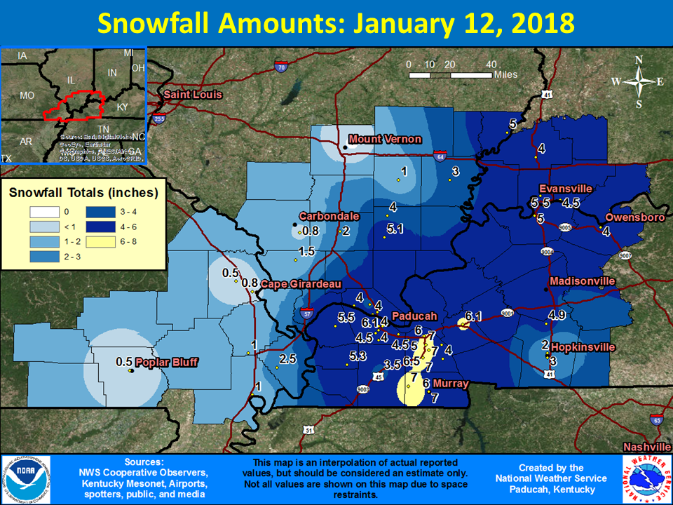
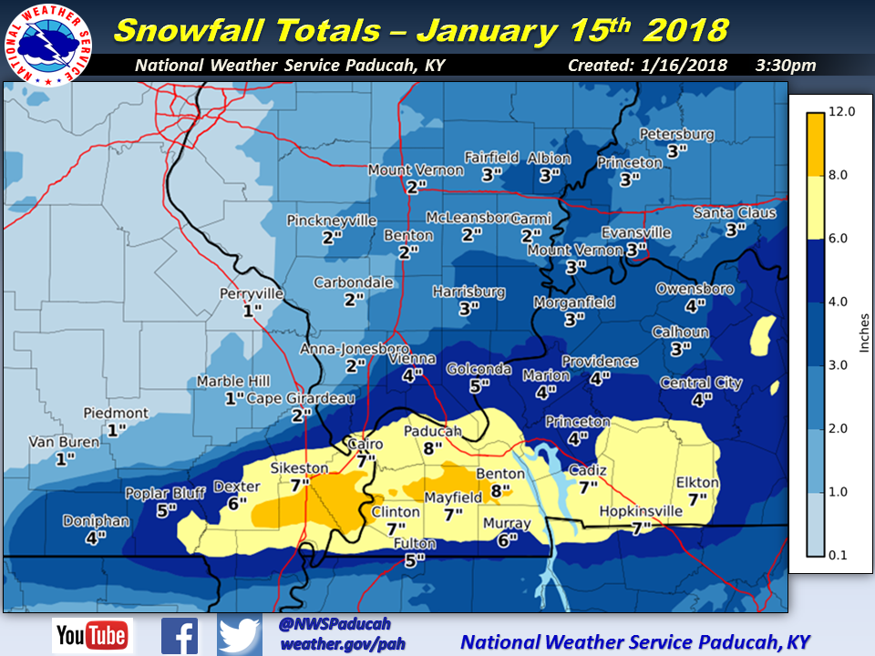
Figure4: This map is courtesy of the NWS of Paducah and shows the snowfall amounts for the 15th.
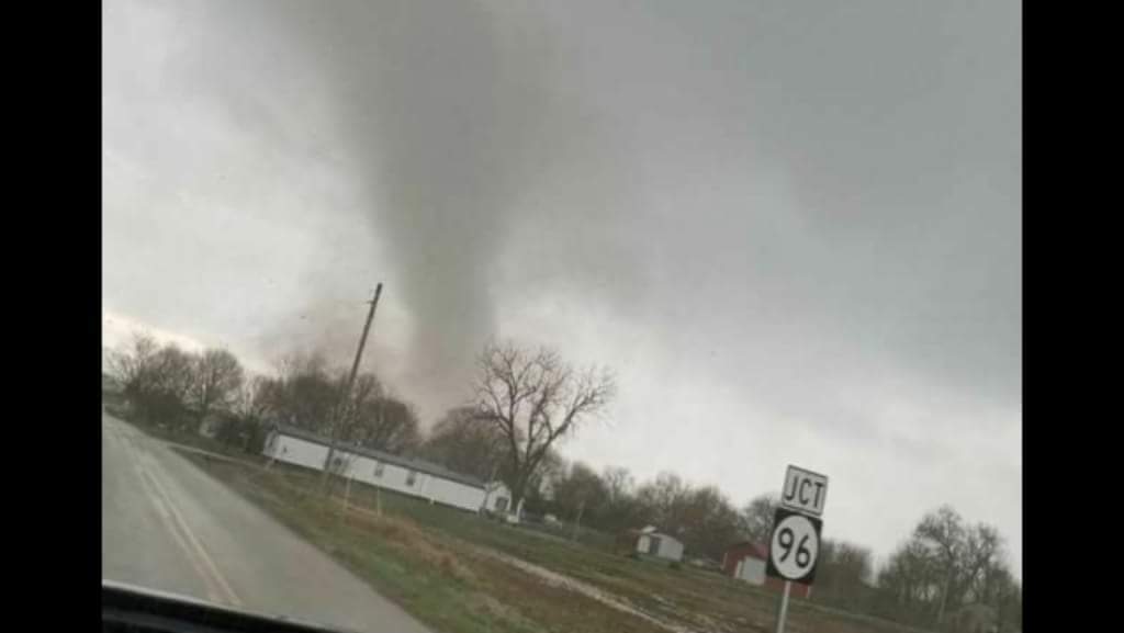
5) Tornadoes of April 3rd
A Moderate Risk of Severe Storms was in effect as a strong system moved across the area. The event featured supercells which produced a EF-2 tornado struck the community of Burna in Livingston County in two EF-1 tornadoes occurred around the town of Clinton in Hickman County and one in Wingo in Graves County. A line of storms produced some wind damage as it moved across Western and Central Kentucky
I wish everyone a Happy New Year and 2019
