
We are back for another winter event on our Top-40 significant weather list, and this time we are back to the era of Grunge, Sitcoms, West-Coast and East-Coast Rap, and Blockbuster Video. With this winter event, I hope you had a VCR ready for those Blockbuster Videos because you likely weren’t going outside for several days.
If you were born between 1980 and January 17th, 1994 and you lived in Kentucky all your life, January 18th and 19th would be the coldest days you would experience in your life as a Kentuckian.
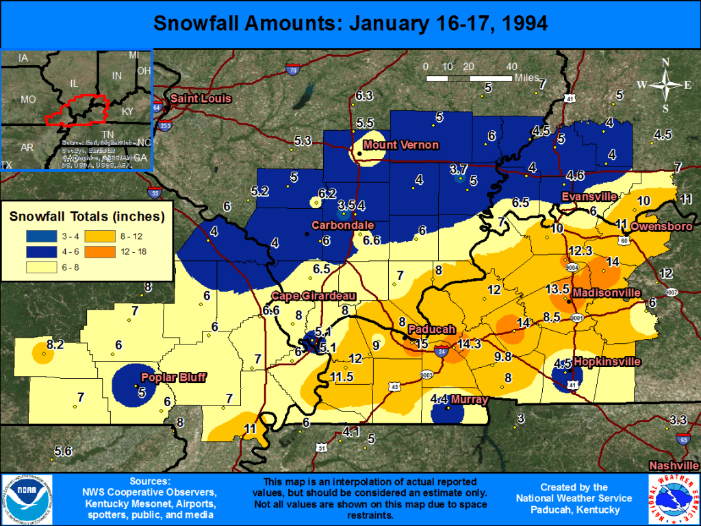
Here are some facts about the January 17th-18th, 1994 winter storm, and associated cold snap, which was the worst cold snap of the 90s.
– From January 14th-21st all stations failed to rise above 36F. With 3 days of near-zero or subzero low temperatures.
– A powerful winter storm on the 16th and 17th produced anywhere from 4 to 15 inches of snow across the area. With the highest locally 12+ inch totals stretching from the Bardwell/Paducah region over into Marion/Princeton/Grand Rivers and then across the Western KY Coalfields region. Such widespread snow totals weren’t observed across a swath of Western KY since the winters of the late 70s, and they weren’t seen again until the pre-Christmas 2004 snowstorm.
– The morning of 1/19/1994 was the coldest part of the cold snap, with all stations recording a low of below -10F. The coldest low being reported in Ohio County of -23F. These were the actual temperatures not factoring in the wind chill.
– In Central KY, Shelbyville just east of Louisville set the all-time record low for the state at -37F degrees.
– Widespread travel conditions resulted as well as damage due to burst pipes and other infrastructure during this event. According to an older weather book I read, Kentucky was even said to have used the most road salt in the 93-94 winter
– A major ice storm did glance our southern/southeastern areas later on in the winter (Feb 10-11th). It almost made our Top-40 list because it did produce significant ice and scattered to widespread power issues from Hopkinsville to Bowling Green and points south and east, but since the worst impacts only impacted a relatively small part of our region, I would probably rank it in the honorable mention #41-#49 range as far as significant western KY weather events. Areas of TN/MS/SE ARK/NW AL were demolished by this ice storm with up to 6 inches of accumulated ice striking the area.
Why Was This Significant
- The heavy snow or snow/sleet mix hampered travel across the area, closed school for 1-2 weeks, and caused economic loss due to loss of productivity alone.
- Just like with the 1917 cold snap significant impacts to infrastructure would occur (although this one had more warning as the modern National Weather Service was starting to form, we had sources like the Weather Channel, and we had computer models and even forms of radar unlike the 1917 event). Frozen pipes would be an issue with temperatures as cold as they were and even though the winds weren’t much of an issue, it doesn’t take much to make an actual -17F reading feel cold, as that is brutally cold for our area on its own. If this were to occur today with even more power usage and even more reliance on technology then rolling blackouts would likely occur due to such high energy demand that would be generated.
