
Our 2025 series continues with a look at a widespread severe weather event, with up to six tornadoes (including 4 that ranked EF-2 and a few injuries). This also kicked off a major flash-flooding and river flooding event that we will discuss in another post.
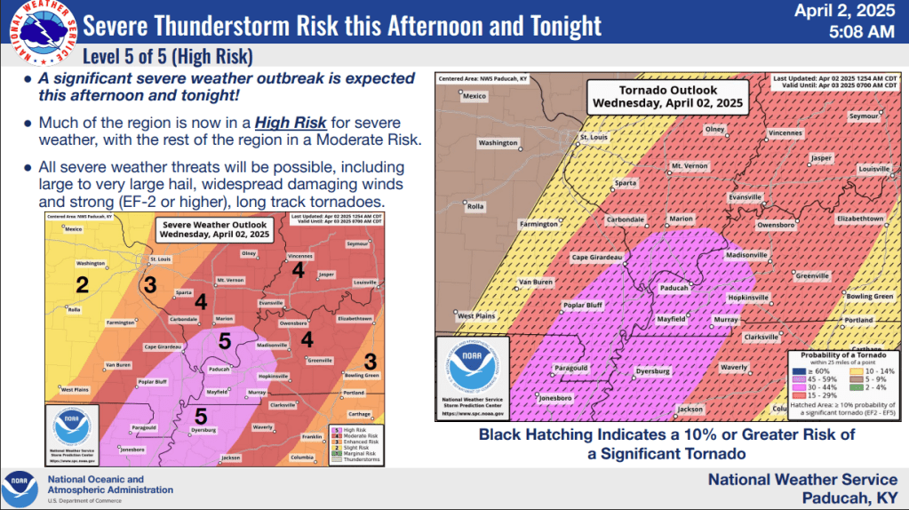
A strong low-pressure system in NW Wisconsin, along with a broad trough, provided ample wind shear (change in wind speed and direction over a large area) and plenty of instability (2000-2750 CAPE) over our area and a large section of the Central and Southern USA. A secondary low-pressure system in NE Arkansas/SE Missouri further enhanced low-level shear across our area and points southwest. Record heat over the Gulf and a broad and slow moving jet streak allowed for multiple systems to produce multiple days of heavy rainfall over the area.
In the late afternoon of April 2nd, a quasi-linear line of severe storms (a squall line with embedded supercell features) formed in Missouri and Arkansas, which merged with some classic supercells that formed in NE Arkansas/SE Missouri before moving into our area. One such embedded supercell tracked across Carlisle County before moving into Ballard/McCracken Counties (producing two separate EF-2 tornadoes). This storm then crossed the Ohio River and produced another EF-2 tornado in Livingston County, just north of Smithland, thankfully passing largely north of town. The EF-2 tornado in Ballard and McCracken County severely damaged a church and caused 4 injuries to a family who were taking shelter at the church. Significant damage occurred to another church, as well as house and business damage on the northside of Paudcah.

Throughout the evening, there were multiple circulations and embedded supercells along the line. If not producing tornadoes, the line produced widespread 50-60+ MPH winds across the area. One moved from NW TN and moved in Murray, producing an EF-1 tornado that thankfully was weakening as it moved into the city. The most impactful was a circulation that produced an EF-1 tornado in the Madisonville area, damaging the Humane Society building, before moving and dissipating between Hanson and Jewel City. Following that storm, an EF-2 tornado touched down and impacted Calhoun proper in McLean County, causing some damage to farm structures, roof damage, and significant damage to power poles in the general area. Thankfully, the strongest winds likely remained just above ground level, preventing an even more significant impact to Calhoun. At one point 10 tornado warnings were in effect at one time from the Owensboro area down into the Trigg/Christian County area.
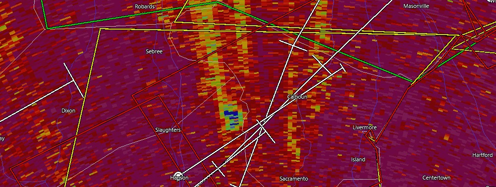
Debris from the Madisonville/Hanson area EF-1 tornado, before forming another tornado in Calhoun.
One of the biggest impacts was that this event produced heavy rain that set the stage for some significant flooding.
