
Setup:
This tornado outbreak was part of a large sequence (very similar to the events of 1995, 2003, and even 2024 to a degree) in which you had a large and very broad-based trough across the western United States. This leads to subtle enough forcing to produce supercell or supercell clusters. On this day a low-pressure system forms over our area, leading to us being near the triple point (where the low-pressure system, warm-front, and cold front meet) leading to enhanced directional wind shear for destructive supercells to form.
The 1917 sequence produced tornadoes from the Central United States through our area and then spreading north into the Midwest and south toward Tennessee and Alabama. This sequence killed over 380 people across the country, produced at least 15 EF/F4+ tornadoes, and likely would have cost several billions of dollars of damage if it were to occur today. This tornado sequence along with one in 1896 are widely considered to be among the worst multi-day tornado outbreak sequences in US history.
Tornado Description:
There are two tornadoes in this outbreak. The first one occurred in Carlisle County around 3:30pm on 5/27 and struck downtown Bardwell as an EF-2. It destroyed one building, caused 2 deaths, and did serious damage in downtown Bardwell.
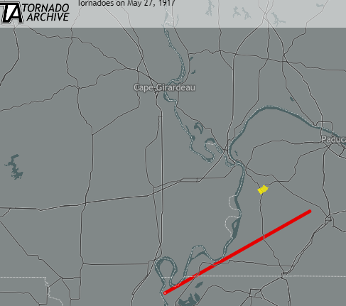
The second tornado and the deadliest single tornado in Western Kentucky’s history (and 2nd in the state of Kentucky) would start near Tiptonville, TN about 30 minutes after the Bardwell tornado. This tornado crossed into Kentucky at KY-94 in Fulton County. This tornado struck the small community of Bondurant (killing 21 people) and then struck the west side of Hickman. This tornado killed 42 people in Fulton County, which is the highest death toll that any county had from a single tornado in our area’s history. There is very little information about this tornado except that it was rated F/EF-4. With such a high death toll and a largely rural area the damage had to be very extensive and high-end.
The tornado then crossed Hickman County before sticking the southeast part of Clinton. This tornado struck Clinton, becoming the 2nd F/EF-4 tornado to hit the city in 27 years, and making Clinton the only town in Western Kentucky to get hit by two violent tornadoes in its history. It caused 17 deaths in Clinton as well. The tornado then crossed into Graves County striking the Dublin area causing 5 more deaths before dissipating somewhere between Fancy Farm and Hickory.
Why Was This Significant:
All and all this tornado caused 65 deaths in a 3-county area in our state. It still stands as the deadliest single tornado in our area’s history as the Quad-State tornado produced 57 deaths (the 2nd deadliest single tornado) and behind 12/10 and 12/11/2021 as the 2nd deadliest tornado day in our area. Since there is such a lack of information about this tornado I can’t go into specific details about its damage, but the community of Bondurant today only has a few standing structures. Suggesting it was at least a slightly larger community back then before the tornado impacted it. The high death toll of this event (especially considering that outside of Clinton and clipping Hickman this tornado went over mainly rural areas of these counties) and the fact that we had a 45+ mile long F/EF-4 both make this a very significant event that we are still discussing over 105 years later. Modern technology and warnings would have very likely saved many of these lives if this event occurred today versus in 1917. The first Tornado Watch wasn’t even issued until 1952 and prior to that it was pretty much forbidden to even use the word tornado in a forecast.
Links (about the sequence):
REFERENCES
Grazulis, Thomas P. Significant Tornadoes 1680-1991. St. Johnsbury, VT: Environmental Films, 1993.
Grazulis, Thomas P. Significant Tornadoes Update 1992-1995. St. Johnsbury, VT: Environmental Films, 1997
- The NWS of Memphis provides the best description of this tornado on the internet at the link below
https://midsouthtornadoes.msstate.edu/index.php?cw=meg – You have to click Lake County, TN to access this description.
