
Today we are going to talk about the worst ice storm on record for most of us (For Hopkinsville to Bowling Green that honor goes to 1951, see event #7). That storm is the January 26th-28th, 2009 Ice Storm and is not only one of the worst winter storms but also one of the worst natural disasters to ever hit the state of Kentucky and this region. The governor at the time Steve Beshear called it at that the time “The Biggest Natural Disaster in Modern Kentucky History” and the Crittenden County official historian called it the “Worst natural disaster in the history of Crittenden County”.
The Setup:
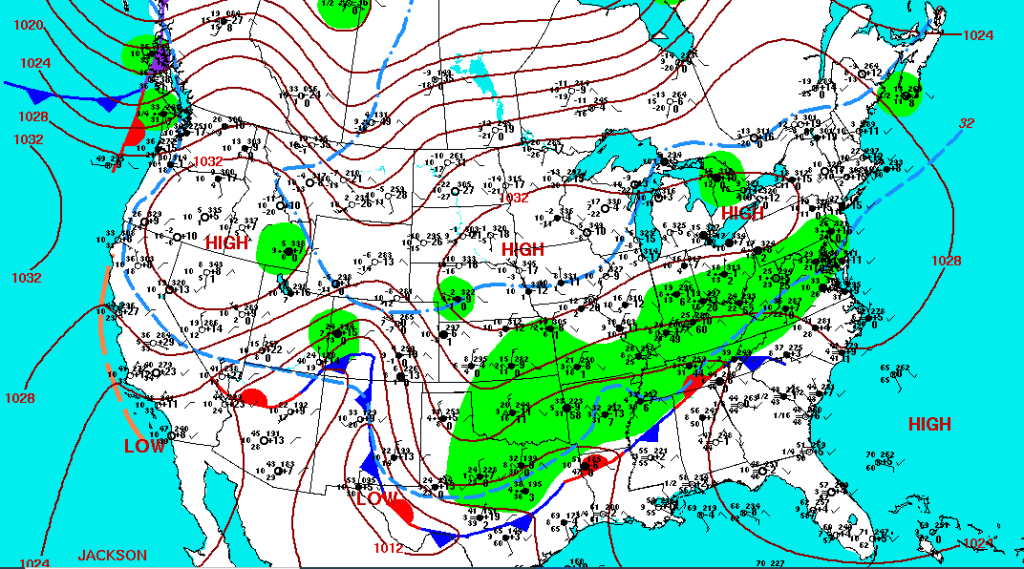
This like our previous ice storms was the result of an overrunning event starting on January 26th followed by one final low-pressure system on the 27th through the 28th. A stationary front was positioned from Mississippi through Southeastern Tennessee with a shallow arctic air mass over our area and a moist and warmer airmass south of the front. Starting on the evening of the 26th waves of moisture were moving along the front leading to the widespread formation of freezing rain. The precipitation fell as freezing rain as the arctic air was shallow, meaning that a layer of above-freezing air was positioned in the mid-layers of the atmosphere causing the snow to melt as rain, but then refreeze at the surface. A low-pressure system on the 27th-28th would finally push this front out, but not until up to 2 inches of freezing rain devastated this area.

Impacts:
Starting in the early-evening of the 26th a steady stream of freezing rain began to spread into the area. This occurred with surface temperatures in the 20s leading to a steady accumulation of ice on roads, powerlines, cars, trees, and any elevated surface across the entire area. The consistent rate caused the freezing rain to be very effective in glazing surfaces, by 11pm on the 26th many of our Jackson Purchase areas were without power, including Carlisle County which was 100% out of power. During the 27th, some warm-air advection did allow for areas from Oak Grove to Bowling Green and points southeast to rise above freezing, but most of us still remained at or below 32F with a shallow airmass to allow for more freezing rain to fall. Many people north/northwest of the Oak Grove to Bowling Green line lost power sometime during the morning of the 27th.
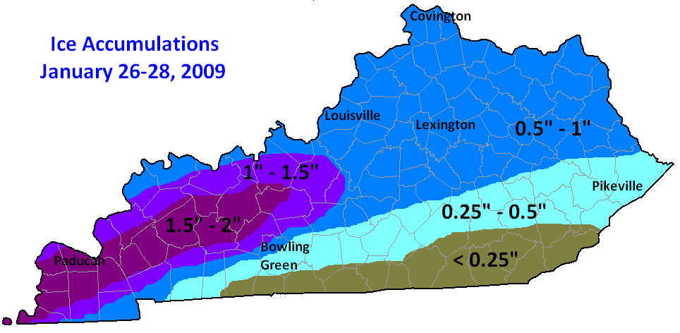
When the low-pressure system moved southeast of our area it did change us to sleet and snow. Producing up to 2-4 inches of sleet/snow along our Ohio River counties and around 1 inch of sleet and snow elsewhere. Total ice accumulations from an 1/2 inch all the way to 2 inches of solid ice occurred north and west of an Oak Grove to Bowling Green line, with about 1/4 of an inch closer to Franklin/Scottsville that melted when they changed over to plain rain. Typically around 1/2 inch of ice is when you start seeing widespread power outages, and when you get in excess of 1 inch is when you see the truly catastrophic damage to trees and powerlines. Many areas such as Bardwell, Beaver Dam, Benton, Central City, Livermore, Mayfield, Madisonville, Paducah, and Princeton were in the zone that saw up to 2 inches of solid ice glaze.
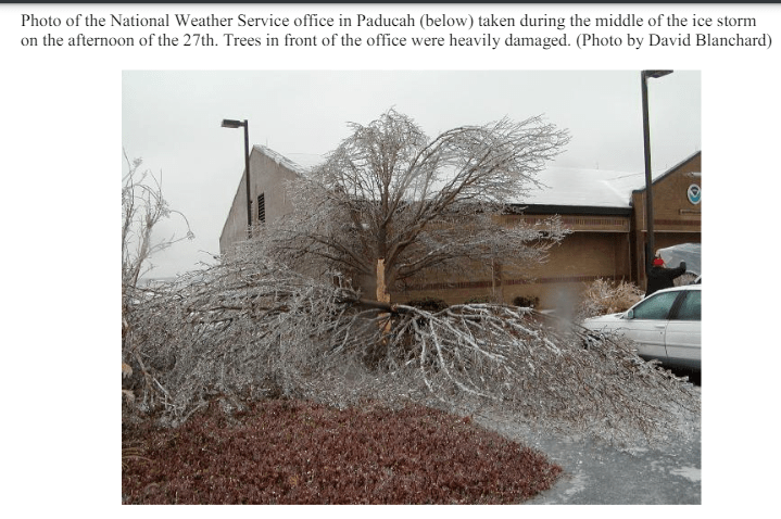
The impacts to travel, power, and communications were major. Cellphone coverage was out across much of our area and many of our counties were shut off from the outside world for multiple days after the storm left. Icy road conditions and especially downed trees led to widespread road closures and people becoming trapped in their section of their county. In some places entire rows of powerlines and powerpoles were destroyed and had to be manually installed. One Jackson Purchase power company stated that 20% of the power grid had to be redone from Ballard to Livingston County. Meaning that many areas that lost power, especially outlying areas were without power for weeks and even in excess of 1 month in a few instances. I even received one report of someone who lived between Cobb and Hawkins (Caldwell/Christian border) who was without power for 72 days. Sadly at least eleven people lost their lives in our area due to hypothermia, not being able to be reached by ambulance during a medical emergency, carbon monoxide poisoning, or heart attacks from removing broken tree limbs. Over 100 injuries may have occurred across the area due to cleanup accidents, breathing in stove gas or carbon monoxide during power outages, and slip and falls. Damage in 2024 dollars was likely well over $500 million dollars from the loss of productivity, to damage to buildings due to falling trees, the cost of repairing powerlines and powerpoles, and removal costs of the massive amount of debris that was generated as a result of this historic winter storm.

Why Is This a Top-5 Event?:
This event along with any of the Top-8 events could have an argument for being the worst weather event in our area’s history. This was the first time that the state of Kentucky called up the National Guard for a natural disaster. For many areas, this is the ice storm of reference whenever a threat of freezing rain or a wintry mix is there. One can say that this is the Dec 10th-11th, 2021 of Winter Storms in our area as it is the one that people still have memories and trauma over even 15 years later. This is truly a storm that will be talked about for generations on end, similar to the winters of the late 1970s and the Flood of 1937.
Links:
^^ Newspaper out of Princeton, KY about the Ice Storm ^^
