

Overview:
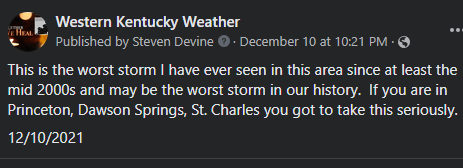
It is probably not a surprise that I voted for the worst tornado outbreak in our area’s history is December 10th-11th, 2021. This was the deadliest confirmed tornado outbreak in our area’s history and it does feature the 2nd and 4th deadliest single tornadoes in our history. This was by far the most destructive event I have ever tracked and the tornadoes of this outbreak, especially the long-tracked one caused by the Quad State Supercell are discussed extensively on science, weather, and tornado forums to this very day.
Setup:
December 2021 was the warmest month on record for our area and much of the Southeastern USA and Lower Midwest. The Gulf of Mexico was also above average as well. This led to the potential for much greater moisture return and instability should a strong enough low-pressure system track to our northwest and take advantage of it.
There was one system on December 6th that took advantage of some of that instability and produced 5 brief (EF-0 and EF-1) tornadoes across our area, including two in Todd County and tornado activity halfway between Wingo and Murray. While that system moved through another significant system was appearing several days later in the models.
As a result of the record warmth and the rich supply of moisture return, we had record-setting storm fuel by December standards. We also had a significant/strong low-pressure system sub-1000mb strengthening to sub-990mb across parts of Eastern Iowa/NW Illinois and into the Great Lakes. The strength of this low-pressure system plus the fact it was gaining strength as the outbreak carried on created a very strong low and mid-level jet. Creating significant wind energy and directional wind shear. Record warmth and high dewpoints were present as well. Dewpoints as high as 68F and temperatures in the mid to upper 70s (some areas in SW TN even hit 80F). CAPE values of 1000-1500 j/kg were present which is almost unheard of in the month of December.
Another factor that contributed to this outbreak was the degree of force. This was a positively tilted/broad-based trough. This means that the forcing for storms was a bit more subtle, so as long as storms could break the CAP the forcing is not enough to initially force a squall line so the storms would be discrete to semi-discrete supercells. Discrete supercells are the most dangerous types of storms as they have uninterrupted inflow that allows for them to last for hours on end and therefore produce long-track and significant tornadoes, which is exactly what happened.
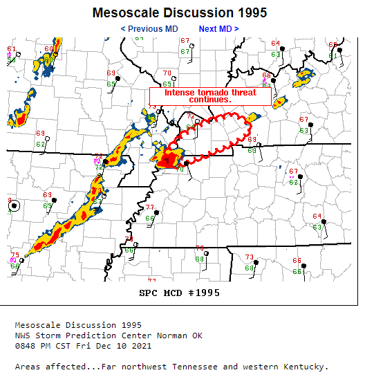
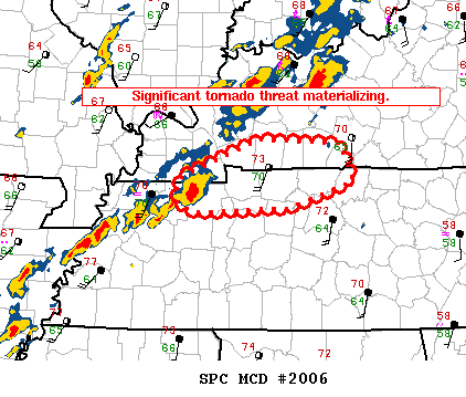
Overall we started on the day before and the morning of with a Level 3 out of 5 (Enhanced Risk) of severe weather. There were still questions on whether the CAP might prevent the earlier supercells from forming along a pre-frontal trough ahead of the cold front. Once it appeared likely that discrete and significant supercells would form in the early evening then the SPC upgraded to a Level 4 out of 5 (Moderate Risk) from Land Between the Lakes and points west and still kept a Level 3 out of 5, with a conditional but very possible hatched/significant tornado risk elsewhere.
The Early Show:
Just after sunset, the CAP broke which allowed for scattered supercells to form. The first Tornado Warning was in part of Graves, Northwest Calloway, into Marshall County. Thankfully that storm didn’t produce anything but a group of supercells formed near a warm-frontal boundary that was moving northward. The only tornado from this was an EF-1 tornado that struck near Central City doing some damage, especially to powerlines in the area and did significant damage to a retail building.
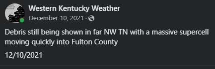
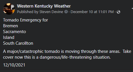
Across the Missouri Boothill and Northwest Tennessee, a long-tracked supercell was moving through the area. A nursing home was hit in far NE Arkansas in the town of Monette and a Dollar General in Leachville, Arkansas. This tornado was caught by storm chasers as being over a mile wide. The SPC issued a Mesoscale discussion at 745pm letting NW TN and far SW KY that a strong to violent tornado was likely with this discrete supercell. Then in far NW TN after a tornado destroyed businesses near Reelfoot Lake and destroyed a fire department in Samburg, TN another mesoscale discussion was issued as it crossed Fulton County and hence began a sequence of events that will be discussed for decades to come.
The Quad-State Supercell and Historic Tornado (Cayce, Mayfield, Marshall/Lyon Counties, Princeton, Dawson Springs, Earlington/Barnsley, Bremen, and Hartford areas):
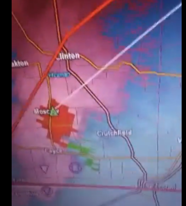
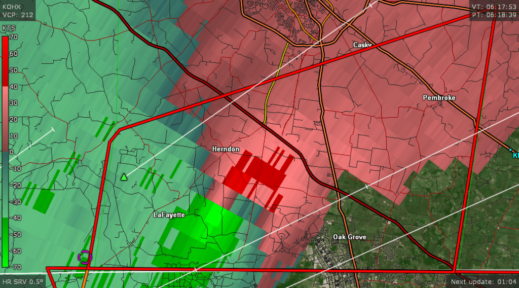
The supercell did briefly weaken a bit in far NW TN, but that changed once it passed Woodland Mills, TN and crossed into Fulton County. The rotation tightened quite a bit and set its sights on the community of Cayce in central Fulton County. The storm began to tighten considerably before striking the community of Cayce head-on. A business was destroyed and several homes were severely damaged in the area producing 1 fatality and 5 injuries across the area with over 60 structures impacted. Once it crossed into Hickman County there were pictures of significant ground scouring and an additional 50 structures were damaged or destroyed.

After the tornado moved through Fulton and Hickman Counties it set its set for the city of Mayfield. This is the most known part of this tornado outside of our area. The NWS of Paducah was issuing tornado warnings with a (PDS) tag meaning that a significant EF-2+ tornado was likely. As the storm pushed closer to Mayfield, the NWS of Paducah issued our first ever Tornado Emergency for our region from the city of Mayfield. Here are some pictures and videos of the warning as the storm hit Mayfield head-on.


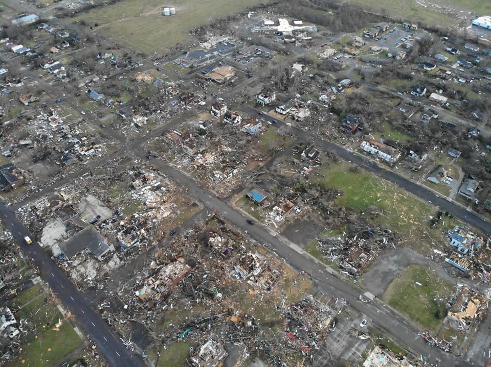
In Graves County, the NWS of Paducah estimates that over 800 structures were completely destroyed and over 2,000 structures were damaged. The most tragic news was that 24 people lost their lives in Graves County with over 200 injuries, which is the 2nd highest countywide death toll in our history (the most being 42 in Fulton County back on 5/27/1917).
Next up was Marshall County and the city of Benton. The tornado did weaken somewhat near Benton as it clipped the northwest part of the city near the hospital. Most of the damage in Marshall County was EF-1 to EF-2 (with some pockets of EF-3 damage just south of Oak Level. The tornado became violent again as it approached Kentucky Lake at Moors Resort and Cambridge Shores. Here 1 fatality and 54 injuries occurred with nearly 700 structures impacted many wiped off of their foundations.

This tornado still being significant moved across Land Between the Lakes damaging thousands of trees across the area before striking several housing developments along Lake Barkley where Lake Barkley and Interstate 24 meet. Here the tornado impacted nearly 200 structures and sadly produced another death before moving into Caldwell County.

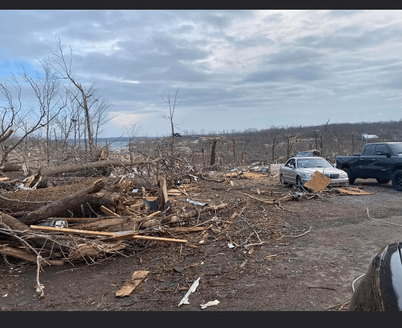
The tornado strikes the south/southeast side of Princeton in Caldwell County. Damaging and destroying at least 300 structures but the number of structures with some type of damage could be much higher. The UK Agriculture Center and Caldwell Mesonet site took a direct hit as did neighborhoods near the country club. This tornado became deadly (4 Fatal) in the eastern part of the country when it struck homes along US 62 just prior to crossing into Hopkins County and striking Dawson Springs head-on.
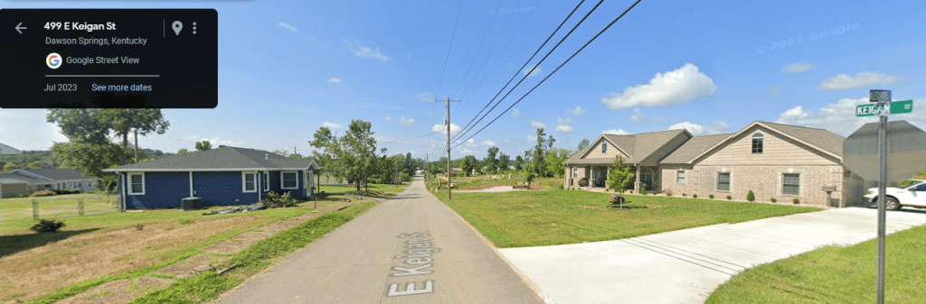
Dawson Springs on the Hopkins County side experienced 15 fatalities in addition to the 4 that occurred on the Caldwell County side. Around 3/4th’s of the residential section of Dawson Springs was leveled including industrial buildings and several low-rise apartments. The tornado was still producing EF-4 (violent) damage at this point. The storm then heavily damaged and destroyed homes in Ilsey and the Barnsley area between Earlington and Morton’s Gap. A train was thrown off of the tracks at this location as well.

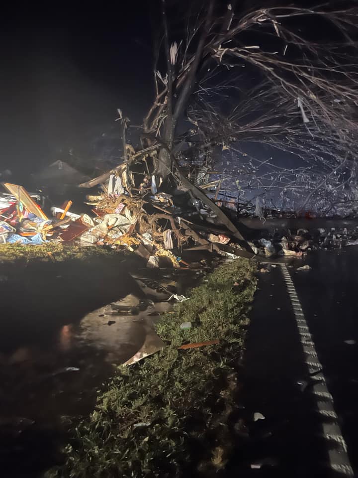
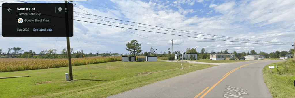
The tornado moved into rural NE Hopkins County and crossed into Muhlenberg County. When it hits the Milport and Bremen area it strengthened again to a high-end EF-4 (potentially EF-5) tornado and was arguably as strong if not even a hair stronger than it was back when it was in Mayfield. A building that was tested to withstand a significant tornado was destroyed in this area of NW Muhlenberg County. Sadly 11 deaths occurred in and around Bremen as the tornado tracked across the northside of town. The most well-known picture of the tornado comes from this location as well. A meteorologist recorded a vrot (measure of wind energy) at a maximum when the storm was over the Bremen area.


The storm then moved into Ohio County doing still significant EF-3 damage to several structures north of Hartford and north of Olaton. It would then move out of our coverage area but still continue as a weaker EF-1 tornado across the Rough River Lake area on the Grayson/Breckinridge County line before finally ending.
This tornado tracking from Woodland Mills, TN near the state line to Rough River Lake Dam traveled 165.7 miles (making it the longest track December tornado on record and the Top-10 in US History as far as tornado tracks go. Another supercell that impacted our area produced the 2nd longest track of any December tornado.
This tornado was the deadliest December tornado in US history, the 2nd deadliest single tornado in our area’s history, the most expensive tornado in our area (likely going over $2 billion dollars in damage), the longest track tornado in our history, and one of the most talked about tornadoes in US history. This storm also lofted debris over 100 miles. Several people in southern Indiana and northern Kentucky reported photos and personal information from Dawson Springs and Bremen.
A truly historic tornado and storm.


The KY/TN border Supercell (including the KY/TN long tracker, Logan, and Bowling Green Tornadoes):
While the Quad State Tornado was moving through Hopkins and Muhlenberg County another long-track supercell formed ahead of a broken line of storms in West TN. This tornado was producing significant EF-3 damage in Kenton and then in Dresden TN before moving into Henry County. This tornado clipped Calloway County near Fort Heimen knocking down some trees before moving into Stewart County impacting the Bumpus Mills and Big Rock general region. The tornado then crossed into SW Christian County while it was on Fort Campbell property and then clipping the southeast part of Lafayette. Tens of structures were damaged and some destroyed as this tornado struck Palyrma Road, passed just north of Oak Grove and Exit 86 on I-24 before directly impacting Pembroke. A few mobile homes were destroyed and an elementary school had significant roof damage flooding classrooms along with several other structures receiving damage. The tornado moved into Todd County as an EF-1 before lifting west of Elkton.
This tornado also tracked over 100 miles at 122.7 miles, making it the 2nd longest December tornado behind the Quad State one. This tornado was rated EF-3, but the damage across our area peaked at EF-2 in southern Christian County.

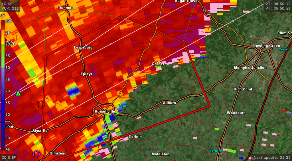
This supercell picked up strength and developed a second EF-3 tornado as it moved into Logan County. This time just to the northwest of Russellville near the community of Epleys. Producing a cluster of EF-3 damage with several structures heavily damaged especially between Highland Lick Road and US 431. This storm moved across northern Logan County crossing KY-79 near Chandler’s Chapel. This tornado caused 1 injury but thankfully no fatalities. This storm moved into NW Warren County just south of Sugar Grove, but didn’t do significant damage. Sadly, this storm would spin up a more damaging storm after 1am that would be quite damaging.
Another very significant tornado would reorganize near the Logan/Warren county line, but this time this tornadic rotation would make a beeline toward Bowling Green.
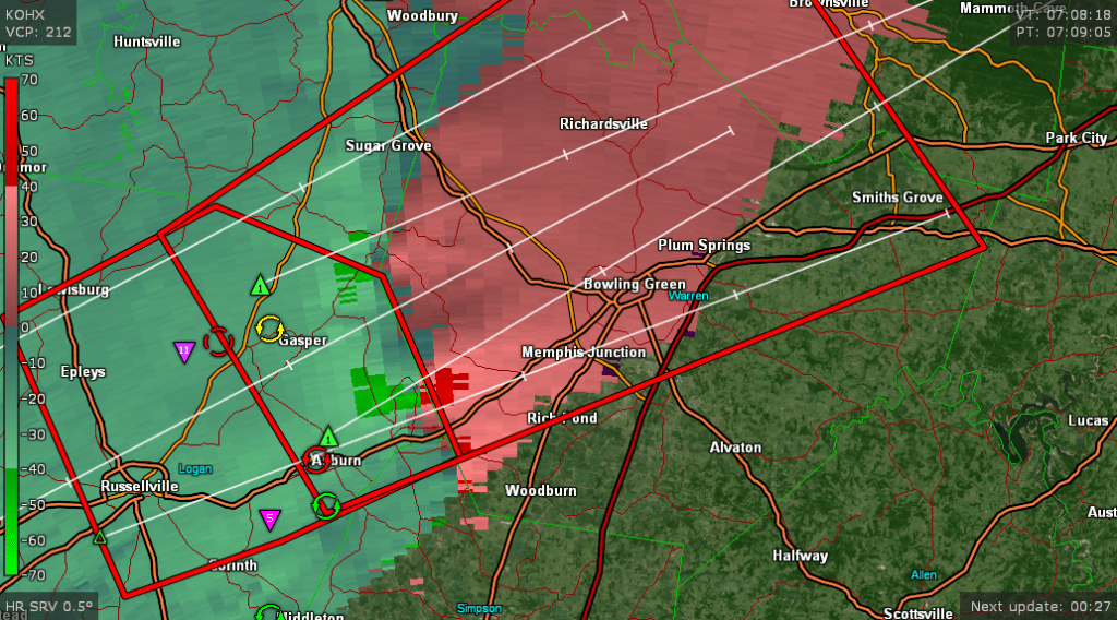
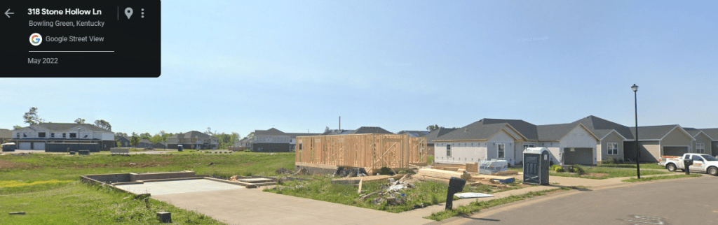
This rotation and tornado quickly took off and just a few miles in produced its first fatality and EF-2/borderline EF-3 damage just north of Rockfield. This tornado was the strongest high-end EF-3 (borderline EF-4) in two main spots in Bowling Green. The first spot was the westside of town from Old Tram Road through the Creekwood subdivision, this is also where it produced the lion’s share of its 17 deaths (16 direct and 1 indirect). Homes in and around the Creekwood subdivision were wiped off their foundation, although due to not great construction quality the tornado couldn’t be ranked higher than EF-3, which is a problem with most modern subdivisions as they are built quickly, especially in a rapidly growing city like Bowling Green. Sadly two homes had multiple fatalities, including one home where 7 different people were killed and another home where 5 people were killed.
The tornado missed the campus of WKU by within a half-mile and instead crossed Russellville RD destroying an Auto Parts store and a Sonic along with several structures before crossing near the Roundabout and moving along US 31-W. Damaging several businesses in the process and doing moderate to locally major damage (mostly EF-1 to EF-2) to several subdivisions. The tornado ramped up to high-end EF-3 (and may have even been briefly up to EF-4) as it struck the industrial park on the east side of the city destroying several buildings. At the same time a satellite tornado (EF-2) formed to the south of the main killer high-end EF-3 and did damage just a few hundred yards away from the main tornado. The Corvette Museum and businesses were damaged and impacted by either the main EF-3 or the EF-2 tornado to its south.
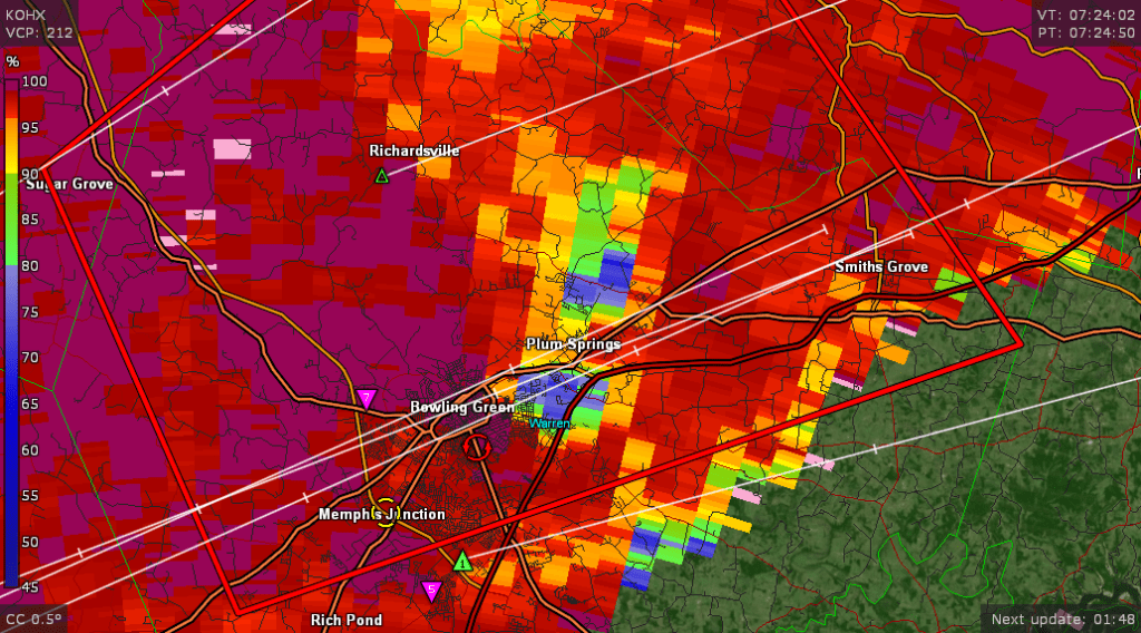
The main killer EF-3 tornado became the 4th deadliest tornado in our area’s history. Combined with the EF-2 was responsible for at least (if not well over) 500 structures being heavily damaged or destroyed with over $100 million dollars in losses. As significant as this tornado was especially impacting the most populated city in our area, it was actually overshadowed a bit by the insanity of the Quad-State Supercell tornado. This tornado would leave our part of Kentucky but would be responsible for several more EF-2 tornadoes and another deadly EF-3 tornado in Taylor County before tracking into Eastern KY and finally weakening. This supercell started back on the Mississsppi River just west/southwest of Dyersburg and tracked almost to the Red River Gorge area of Eastern KY.
Why Was This Significant:

As I stated in previous posts it is hard to lose property to a natural disaster, but it is much harder when you lose a person you care about. People cannot be replaced and grief is a life-long process. This outbreak was the deadliest tornado outbreak in our history meaning that from 9pm on 12/10/2021 to 2am on 12/11/2021 we lost more people to severe weather than any other severe weather event. Storm trauma even for those who did not lose a loved one will be something that many of us will experience for the rest of our lives in this area, very similar to the trauma caused by the 2009 Ice Storm.
We also lost people in multiple counties with fatalities being reported in Graves (24), Warren (16), Hopkins (15), Muhlenberg (11), Caldwell (4), Fulton (1), Lyon (1), and Marshall (1). A few of these counties also had indirect fatalities due to heart attacks or health conditions while taking cover or helping with storm cleanup. The only time we had eight or more counties that reported tornado/storm fatalities was during the Mid-Mississippi River Valley Outbreak of 3/27/1890.
The Quad-State tornado was the most expensive tornado in our history and the Bowling Green tornado is about as costly as the 2000 Owensboro tornado.
This event is still discussed to this day and will be discussed among weather circles. The Quad-State Tornado was likely one of the worst tornadoes to ever occur in the world since the Moore, OK (2013) tornado. It could have very well been an EF-5 tornado as well, but the quality of construction was in question across many of the buildings therefore keeping the tornado a high-end EF-4. Regardless of the rating the significance and life-long impact of this tornado is not in question.
Recovery:
In the days that followed many residents either stayed with siblings or at shelters as tens of thousands of people had homes that suffered damage due to the storm. Over $52 million dollars were raised from the Team Western Kentucky Tornado Relief Fund created by the Beshear Administration. Many Go Fund Me’s were also created and a relief concert raised money in August of 2022.
Throughout 2022 debris removal also occurred including the removal of 1.2 million pounds of tornado debris from KY Lake.

As tragic as the event was there were several instances of generous behavior in this event. Here are just some of the examples. It really showed us what it means to be an American and a Kentuckian.
- Inmates on Work Detail in Mayfield stayed back to help pull victims out of the rubble at the Candle Factory, one who suffered injuries came back while injured to save more people in the collapsed building.
- Multiple people held donations for Christmas toys to help salvage some sort of Christmas for tornado victims
- Relief groups came from multiple states to help with cleanup and donations.
- A Facebook group was created to reunite tornado victims with their prized possessions and pictures, in some cases that were lofted up to 150-200 miles away from their original location
- Excellent performance by the National Weather Service, Storm Prediction Center, and local media for both their during storm-coverage and post-storm coverage. If it wasn’t for their warnings the death toll for this event would have likely exceeded 200 across our area.
- Schools that were in session spent a good chunk of their week before Christmas making care packages and Christmas cards for students that were in the impacted areas.
Overall this is a historic tornado event that I hope will never be repeated and will not be forgotten.
Links:
https://www.warrenpc.org/webmaps/disastermaps/
^^ Disaster map and pictures of the entire Bowling Green track ^^
^^ A children’s book written by a high school student in Dawson Springs was influenced by the tornado ^^
https://www.tornadotalk.com/the-immeasurable-cost-of-the-december-10-11-2021-tornado-outbreak/
^^ This reading gives details about the tornado, several tornado pictures, and has a place of remembrance for all of the people who lost their life during these tornadoes. This is a read that will likely cause you to shed some tears so keep that in mind ^^ Also a Weather Brains episode featuring several meteorologists from the area.
https://www.weather.gov/pah/December-10th-11th-2021-Tornado
The NWS of Paducah summary
https://www.weather.gov/lmk/December112021Tornadoes
The NWS of Louisville summary
