

Summary:
We finish our all-time Top-40 series with the Great Flood of January-February 1937. Just like 2009 is the top-dog event for winter storms, December 10th-11th, 2021 is the top-dog event for tornadoes/severe weather, and January-February 1937 is the top-dog event for flooding in our area and ended the dust-bowl era droughts for our region.
The Setup:
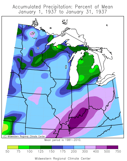
January 1937 was one of the wettest months on record for our area, with some areas receiving over 20 inches of rainfall. Bowling Green observed 20.7 inches of rainfall and Earlington observed 23 inches of rainfall for the month of January. Since we have low sun angle during the winter time our evaporation rates are much lower versus late Spring or Summer. In addition, several areas received accumulating sleet at one point during the month, which did not allow for heavy rain to infiltrate the soil and instead went to our river system as runoff. As a result record flooding occurred on all of our major rivers, but especially hard-hit were the Ohio, Green, Cumberland, and Tennessee rivers.
The Impacts:
The Ohio River crested at 60.6 feet at Paducah, a record that still stands to this day. Record flooding occurred along the Green River from Woodbury through Calhoun with records that still stand to this day. Most of the Ohio River record crests were from 1937 with only a few stations breaking those records in the 2011 flood. Also hard hit was the between the rivers area (which is now Land Between the Lakes more on that later) as major flooding of both the Cumberland and the Tennessee River.
Toward mid to late January evacuation orders were already in place. As a result of the Ohio River flooding around 95% of the city of Paducah went underwater by the end of the month, including the entire downtown region. The economic costs of a similar flood today would be north of $600 million in 2024 dollars for just the Paducah area alone. As observed in the featured picture above, travel across Paducah was only possible by boat. Nurses gave residents Typhoid shots and people were rescued from their rooftops as the floodwater pushed into the 2nd story. In some areas along the Ohio River, the water got as high as telephone poles. Several fatalities (exceeding 10) sadly occurred in Paducah and along the Ohio River although the exact number in our area is unknown. The Ohio River peaked on Feb 2nd in Paducah then slowly began to recede. Other places along the Ohio River experienced major flooding with Owensboro seeing over 30 intersections covered by floodwater. Significant flooding impacted both the Evansville and Henderson area, and places along the river in Crittenden and Union County had to flee to higher ground, with the town of Shawneetown in SE Illinois having to relocate further away from the Ohio River due to the massive flooding. This also led to flooding along the Mississippi River which was impacted by a major flood in 1927 with flood impacts across Ballard, Carlisle, Fulton, and Hickman Counties, although a levee in Hickman saved the area from much worse damage.
Across the Green River record flooding occurred. Most of Woodbury in Butler County was likely under water, significant flooding along the Barren River (a tributary of the Green) caused enough flooding in Bowling Green to trigger a National Guard response, and over 60% of McLean County was underwater during this event for the Green River and the small tributaries across the county. Travel was restricted to boat in parts of NE Hopkins and likely eastern Webster Counties, and at least 1 fatality occurred in this area during a rescue operation. Record crests along the Green River have yet to be exceeded even by the 1937 and 2011 floods.
Some of the worst flooding outside of the Ohio River occurred along the Tennessee and the Cumberland River. The towns of Kuttawa and Eddyville largely went underwater due to the combined major flooding of both rivers. Dycusburg in southern Crittenden County became completely surrounded by water and required outside rescue. The major flooding in this area although with flood control programs passed by Congress and signed by Franklin D. Roosevelt caused the cities of Eddyville and Kuttawa to relocate to higher ground.

Why Was This Significant:
If a flood like this were to occur today and we only had what we had in 1937 (as far as not having floodwalls or flood control methods) then damage would likely be over $2 billion dollars and would rival the December 2021 tornado outbreak as the costliest event in our area’s history.
This event and the reason why I have it at #1 is because this event transformed our area and life in this area as we know it. The Flood of 1937 was one of the main reasons that led to the relocation of Kuttawa and Eddyville to higher ground, as well as the creation of the Land Between the Lakes as a form of flood control mainly, but it also became a popular recreation area that is visited by people from across the country. This also meant that people in communities like Birmingham and Golden Pond had to move on to other communities as those areas were flooded by the creation of Land Between the Lakes.
For Paducah and several places along the river this led to the creation of the flood wall. Without the floodwall as the result of the 1937 event then Paducah would have experienced much worse damage from the 1997 and 2011 floods.
Links:
https://web.archive.org/web/20080604134934/http://kyclim.wku.edu/factSheets/ohioRiver.htm
^^ WKU Fact Sheet ^^
https://en.wikipedia.org/wiki/Ohio_River_flood_of_1937
McKenzie Martin, “The 1937 Flood,” ExploreKYHistory, accessed July 1, 2024, https://explorekyhistory.ky.gov/items/show/369
https://www.facebook.com/watch/?v=10155708738734018 – Paducah video in 1937
https://dcpl.contentdm.oclc.org/digital/collection/p17056coll1/id/131/ – Flood pictures form Owensboro
NWS of Louisville poster (link below) https://www.weather.gov/media/lmk/pdf/flood_37/GreatFlood1937_Poster.pdf
