
We are now in our top 20 significant weather events. We have already seen how significant the events from #21 through #40 are and how we are truly starting to get into some of our most historic, deadly, and catastrophic weather events.
Following a pretty cold winter (1963-1964) we start to see a Springtime pattern emerge in early March. This event begins on March 4th with a strong low-pressure system tracking across Arkansas/Southeastern Missouri. The slow movement of this system, plus its near due north movement is allowing for heavy rain and thunderstorms to move over the same areas, Western Kentucky in particular. As this low moves into Southeastern Missouri it is bringing 60+ dewpoints into the area along a warm front feature. Wind shear is very high so severe storms form across the area. Overall this setup is very similar to the Owensboro Tornado setup of 1/3/2000, with the strength/direction/general track of the low-pressure system. The main impact being two significant tornadoes and a few damaging wind reports.
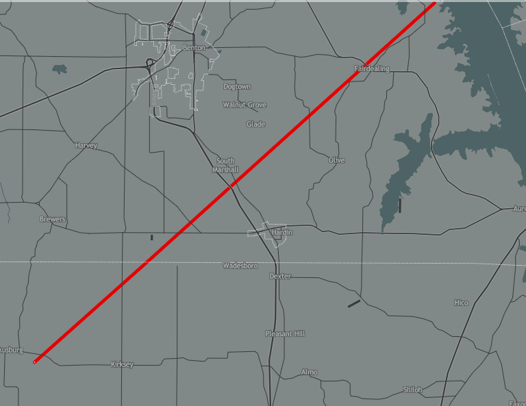
The first of the two tornadoes touches down near Kirksey in NW Calloway causing 8 injuries before picking up strength and moving into Marshall County. The tornado (F/EF-4) moves just north of Hardin before hitting the Fairdealing community head-on and missing the community school by yards (it was around lunchtime on a Wednesday so that could have been an even worse disaster). Overall 3 deaths and 16 injuries occurred in Marshall County, making this the deadliest tornado of the 1960s. Over 30 structures/homes were destroyed or had major damage.
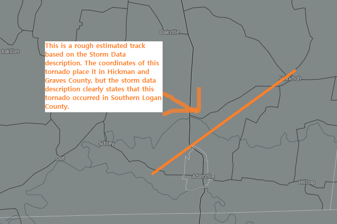
The second tornado occurred about 3 hours later in southern Logan County, likely along or just south of the warm front. This was a half-mile-wide F/EF-3 tornado that nearly missed Adairville but caused significant damage to properties on the northern/western outskirts of town before moving into the Schochoh community and lifting in the southeast part of the county.
This event also produced a widespread 2-6 inches of rain across the area, and a later event a few days later also produced a widespread 2-6 inches of rain. That means that some areas in a week saw 10-11 inches of rain. Without the plant life that occurs later in the Spring which helps prevent erosion a lot of this rain creates runoff into the Ohio, Clarks, and Green River. The Clarks River caused significant flooding across the Jackson Purchase area, and the Ohio and Green River reached their highest levels since 1937 in some places leading to properties flooded near the river, with Lewisport in Hancock County being hard-hit. Backwater flooding in residential areas surrounding Paducah also occurred.
Why Was this Significant
- The tornado event on March 4th, was one of the most damaging tornado events in the 1950-1999 timeframe in our region. It also was a rare F/EF-4 tornado which only a very small number of outbreaks in our area feature.
- The flooding was some of the worst in the 1950-1995 timeframe with many points along both the Ohio and Green River recording between their 3rd and 10th highest river crest of all-time during this event.
Link With More Details About This Event From the USGS:
