
We talked about the worst tornado event in November previously, the number #9 event is the worst tornado event to ever occur in February. As this event was able to kick-off it was also the Super Tuesday primary elections. Kentucky didn’t have a primary that day but several states that were impacted like Arkansas and Tennessee did have primaries but thankfully most voters returned home before severe weather broke out.

The Setup
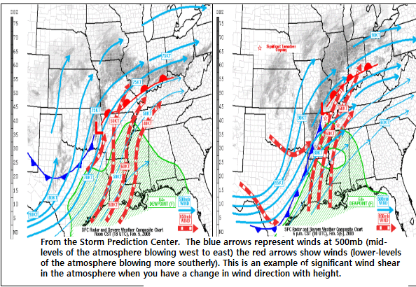
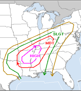
2008 just like 2007 is the only year to have 3 different events make our Top-40 all-time significant weather events. One reason why this timeframe was so extreme was due to our area being in the battleground zone between a brutal cold airmass in IA/WI/NW IL and a warmer and drier airmass across parts of the Southeast into South-Central TX. That allowed for constant storms to form in our general area as this airmass clashes across the southeast ridge. This setup also contributed to a major ice storm just 1 week later. The October 2007 through April 2008 timeframe was one of the most extreme timeframes in Western KY history. Super Tuesday featured a very strong low-pressure system across Arkansas and Missouri, with an unseasonably warm airmass present moving into our area featuring 80F temperatures as far north as TN. While this occurred a strong low and mid-level jet stream were moving into the area, and the winds changed from southerly to westwardly as you went up into the atmosphere. All of these factored into the Storm Prediction Center putting the area in at least a Moderate Risk of severe weather which was then upgraded to a High Risk for the western 2/3rds of our area by 10:45am.
There was also a CAP positioned in our area. This is a mid-level warm layer that prevents storms from uplifting. The problem is that the CAP helps prevent early storm convection meaning that our area can build up ample instability. When the CAP broke it allowed for scattered storms to form in the open warm-sector. This allowed for supercells to stay discrete until a squall line would catch it much later in the overnight hours. That allowed for up to 6 hours of discrete supercell formation.
Round One:
Around 5pm on the 5th a supercell formed in NW Tennessee. This produced a tornado in Weakley County TN (EF-1) before moving into Calloway County around 6pm. This supercell quickly produced 3 tornadoes all EF-1 in rating in Calloway and Trigg County causing damage to trees and a few homes. The supercell picked up strength in Christian County touching down south of the Pennyrile Forest before striking the town of Crofton. This caused at least 6-7 million dollars (in 2024 equivalent) with over 40 homes/structures impacted.
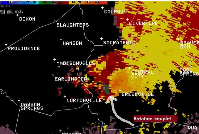
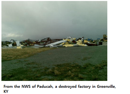
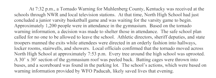
The strongest tornado from this supercell occurred in the heart of Muhlenberg County. The tornado struck just southwest of Greenville before moving into Greenville sadly producing 3 deaths in a mobile home park, Powderly, and the east side of Central City. 69 homes were destroyed and 200 were impacted, including the industrial park, which is where the destroyed factory picture above came from. The life-saving warnings from the National Weather Service of Paducah and the decision-makers at the former Muhlenberg County North High School likely saved several lives as a tornado passed by the high school as a game was going on. This could have been a mass causality event that was avoided due to the life-saving actions of the National Weather Service and the leadership at the school.
Round Two:
The squall line along the cold front charged through the area between 11pm-3am. This line produced pockets of 75MPH+ wind gusts with downbursts up to 95MPH in Carlisle County and Southern Christian County. The damaging storm was a supercell that formed ahead of the line in Middle TN. This storm moved into the Amos community of SE Allen County, causing 4 deaths (becoming the deadliest single tornado since 1942 for our area until December 2021) before crossing into Monroe County and lifting. Some pockets of flash flooding also occurred in the Evansville Tri-State region.

Why Was This Significant
- This event along with the January 2000 and November 2005 events, showed us that we need to be weather-aware all year. Remember that the atmosphere doesn’t care about what day is it on the calendar. It can be June, December, or April, but if the conditions are favorable for tornadoes then we need to be weather aware.
- This event was the 2nd deadliest modern tornado event in Western KY’s history (I define modern as being 1950 or later as that is when modern tornado records began) with 7 total deaths. Deaths are way more impactful than property loss because you can’t replace a person. That is why this event made it into the Top-10.
Links
https://www.14news.com/story/7827725/february-5th-2008-damage-reports/
^^ 14 News article was some pictures ^^
^^ Murray article ^^
https://www.flickr.com/photos/perspectivephotography/albums/72157603878143830/with/2253239095
^^ Pictures of the damage in Muhlenberg County ^^
